The MAFA 2025 conference will be held at Millersville University, Millersville, PA. This university campus is located in south-central Pennsylvania’s historic Lancaster County.
Directions to Millersville University
Download driving directions to Millersville University as a PDF
Download a map of the campus as a PDF
Google Maps Link: maps.app.goo.gl/H6TnRfcf5ttu4Hqw9
If you need to use an address, use: 383 Shenks Ln, Millersville, PA 17551.
GPS Coordinates to Millersville University
Use these GPS coordinates to take you directly to the entrance for Registration and the Marketplace in the Student Memorial Center on campus:
- N 39°59.701′
- W 076°21.201′
Check-in Instructions – Registration opens at Noon on Thursday
Download the Conference Contacts, Check-in, and Directions to Unloading at Classrooms as a PDF
Click here to check out the video of directions to Registration and the dorm
Wednesday arrivals: We will email you instructions.
Where do I go when I arrive on Thursday to check in for the conference and get a key for my room?
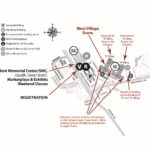
Your first stop after parking should be the conference registration desk in The Marketplace at the South end of the Student Memorial Center that faces the parking lot. You will receive your dorm assignment, and a tote with your: goody bag, name badge, attendee directory, and handouts.
UPDATE: After registering with MAFA and getting your room assignment, proceed to the West Village Dorm, first floor Wing A or Wing B check-in desk, to get your meal/key card and room key.
Then, head to your classroom building to unload your equipment, see directions below.

Directions to Unload at Classrooms – Starting from Registration Parking Lot
Download the Conference Contacts, Check-in, and Directions to Unloading at Classrooms as a PDF
Click here to check out the videos of directions to the classroom buildings
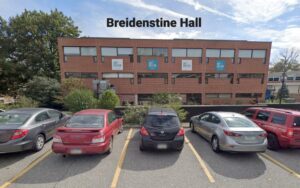
Unloading for Breidenstine
46 E Frederick St, Millersville, PA 17551: maps.app.goo.gl/m1heTpZbNxzGALKm9
- Exit the West Village Parking lot making a LEFT turn onto Centennial Drive
- Turn LEFT onto Pucillo Drive for 0.4 miles
- Turn RIGHT onto Creek Drive for 100 yards
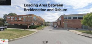
- After Pucillo curves to the left, park if unloading in Breidenstine Hall, or pull down the driveway to the loading dock between Breidenstine and Osburn.
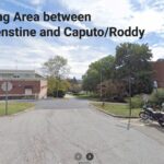
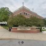
Unloading for Caputo North/Roddy – 200 Level
Science Ln, Millersville, PA 17551: maps.app.goo.gl/LZQzxZxorrx6UWG1A
- Exit the West Village Parking lot making a LEFT turn onto Centennial Drive
- Turn RIGHT onto Creek Drive for 100 yards
- Turn LEFT onto Pucillo Drive for 0.4 miles
- After Pucillo curves to the left, park on the street, or pull down the driveway to the loading area on the North side of the building.
Unloading for Caputo South/Roddy – 100 Level
50 E Frederick St, Millersville, PA 17551: maps.app.goo.gl/HFzXh4tXrVLFKqoE7
- Exit the West Village Parking lot making a LEFT turn onto Centennial Drive
- Continue straight onto Creek Drive
- Pass James Street
- Continue as Creek turns LEFT to become E Frederick Street
- Park on the street to enter the South side of Caputo
- The sign will say Agires Science Complex
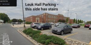
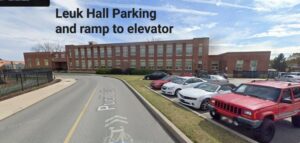
Unloading for Luek Hall
24 Pucillo Dr, Millersville, PA 17551: maps.app.goo.gl/ZhBiURLt1q3QsNRs8
- Exit the West Village Parking lot making a RIGHT turn onto Centennial Drive
- Turn RIGHT onto Shenks Lane
- Turn RIGHT onto E Frederick Street, go through the light crossing George Street
- Turn LEFT onto High School Avenue
- Park on the right for Leuk OR
- If unloading for Luek, continue straight ahead and park behind Luek Hall (on your right)
Unloading for McComsey Hall – 100 Level
18 Creek Dr, Millersville, PA 17551: maps.app.goo.gl/kpK7gvCNNhkG5jgL7

- Exit the West Village Parking lot making a LEFT turn onto Centennial Drive
- Continue straight onto Creek Drive for 100 yards
- Pass James Street, then park on the street, or turn LEFT into the service area at the lower level of McComsey
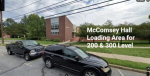
Unloading for McComsey Hall – 200 and 300 Levels
45 James St, Millersville, PA 17551: maps.app.goo.gl/HYdDrvGbEs25TnHn8

- Exit the West Village Parking lot making a LEFT turn onto Centennial Drive
- Continue straight onto Creek Drive for 100 yards
- Turn LEFT onto James Street
- Pass the tennis courts, then turn RIGHT into the parking lot next to McComsey
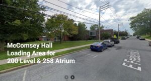
OR Alternate Unloading for McComsey Hall – 205, 258 Atrium, 305
40 E Frederick St, Millersville, PA 17551: maps.app.goo.gl/Qp7oivLBHuuTazK99
- Exit the West Village Parking lot making a LEFT turn onto Centennial Drive
- Continue straight onto Creek Drive
- Pass James Street
- Continue as Creek turns LEFT to become E Frederick Street
- Park on the street to enter the North side of McComsey
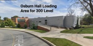
Unloading for Osburn Hall
45 Pucillo Dr, Millersville, PA 17551: maps.app.goo.gl/2t4Bfk2p2kzeqbDAA
- Exit the West Village Parking lot making a LEFT turn onto Centennial Drive
- Turn RIGHT onto Creek Drive for 100 yards
- Turn LEFT onto Pucillo Drive for 0.4 miles
- After Pucillo curves to the left, park on the street behind Breidenstine Hall, or pull down the driveway to the loading area between Osburn and Breidenstine.
Unloading for SMC – Weekend Classes Only
112 Shenks Ln, Millersville, PA: maps.app.goo.gl/2NxaLUftNsK5MFpn7
- Exit the West Village Parking lot making a RIGHT turn onto Centennial Drive
- Turn RIGHT onto Shenks Lane for 250 yards
- Park if unloading in SMC